
Short answer: three kinds of ground meet around Sugar Land. Along the Brazos, including most of Sugar Land itself, it's river clay that swells and shrinks all the way down. Across the coastal prairie around it, it's clay too, a little less active but almost everywhere. Up toward Katy and Cinco Ranch, it's sandy on top, over clay loam that moves far less. Which one your house is on changes what a crack can mean, and the USDA's free soil map will tell you.
Key facts
- On the state geologic map, 19 of our 25 Sugar Land sample spots landed on river deposits. Brazoria clay, the main river soil, reads 17 on the USDA's shrink-swell scale in every layer down to about 80 inches.
- Across 13 prairie towns, 266 of 322 sample spots came up high or very high for shrink and swell. On the Katy terrace, 19 of 73 did.
- Pledger clay reads 19 in its top 17 inches, the highest reading in all 22 towns we studied.
- None of the main soils in the area has bedrock within about 6½ feet of the surface.
Why Three Kinds of Ground Meet Around Sugar Land
The ground around Sugar Land was laid down by water, in three different eras. The US Geological Survey's state map shows each one as its own unit.
The youngest is the river bottom. The USGS describes its alluvium simply as deposits "along streams," a mix of sand and silt with clay and gravel. Along the Brazos, the soil survey is more specific. It says Brazoria clay formed in clayey sediments "on the flood plains of the Brazos and Colorado Rivers," and it ties Pledger clay and Norwood loam to the same rivers.
Older than that is the coastal prairie, mapped as the Beaumont Formation. It's Ice Age clay and silt with beds of fine sand. The USGS says it includes "plastic and compressible clay and mud" laid down in flood basins, coastal lakes and old stream channels. Lake Charles, Bernard and Edna, the prairie's main soils, all formed in it.
The oldest of the three is the Lissie Formation, which the USGS says "dips seaward beneath" the Beaumont. Around Katy it comes to the surface as a flat terrace, and Katy, Clodine and Cyfair soils formed in its loamy sediments. Neither formation is named for anything nearby. The Beaumont takes its name from the city of Beaumont, and the Lissie from Lissie, in Wharton County.
How we checked the ground
We placed 25 sample spots around each of 22 towns, Sugar Land included, on a grid about 5½ miles north to south and 5 miles east to west. Each spot got two look-ups: its rock unit on the USGS state map, and its main soil in the USDA survey. Of the 550 spots in total, 540 fell on land and the other 10 on water. Treat the result as a portrait of each town as a whole. It can't speak for a single street or lot.
The USDA rates how much a soil grows and shrinks between moist and dry, with a measure called linear extensibility. The bands run from low (under 3) through moderate (3 to 6) and high (6 to 9) to very high (9 and up). Each spot was scored on its soil's peak reading anywhere in the top 2 meters, about 6½ feet.
To picture a reading of 17, take a dry 10-inch lump of Brazoria clay. Soak that lump and it grows to roughly 11.7 inches long. A lump of the clay loam under Katy soil, which reads 3.8, would grow to about 10.4 inches. The lab dries soil in an oven, so these numbers compare soils rather than predict how far a house will move. Still, the USDA says that once a soil rates moderate or higher, shrinking and swelling can damage buildings.
Three kinds of ground, side by side
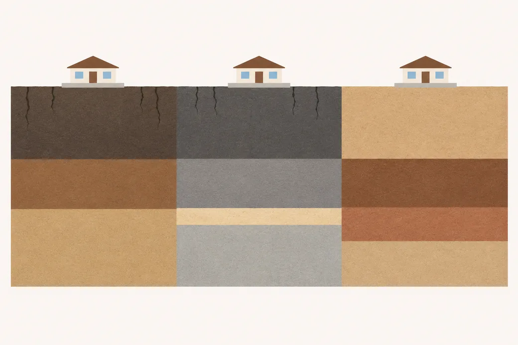
- River bottom: dark clay that cracks near the surface, over layers of river silt and sand
- Coastal prairie: dark clay that cracks near the surface, over gray clay and silt with a thin bed of sand
- Katy terrace: a sandy top with no cracks, over a layer of clay loam
Town by Town: How Much Swelling Soil
We checked 25 spots in each town. A few landed on water, so some towns have 23 or 24. Below, each town's spots are split three ways, by the kind of soil they landed on, and the three numbers add up to the town's total. The more very high spots a town has, the more of its ground is the clay that moves most. Towns are grouped by the ground most of each one sits on, with the most very high spots first.
River bottom
- Sienna (25 spots): 18 very high, 2 high, 5 moderate or low
- Sugar Land (23 spots): 16 very high, 1 high, 6 moderate or low
- Simonton (25 spots): 14 very high, 0 high, 11 moderate or low
- Richmond (25 spots): 13 very high, 6 high, 6 moderate or low
- Pecan Grove (24 spots): 11 very high, 4 high, 9 moderate or low
- Weston Lakes (23 spots): 9 very high, 3 high, 11 moderate or low
Coastal prairie
- Iowa Colony (25 spots): 21 very high, 1 high, 3 moderate or low
- Pearland (25 spots): 14 very high, 7 high, 4 moderate or low
- Missouri City (25 spots): 14 very high, 4 high, 7 moderate or low
- Meadows Place (25 spots): 13 very high, 8 high, 4 moderate or low
- Four Corners (24 spots): 13 very high, 5 high, 6 moderate or low
- Fresno (25 spots): 12 very high, 12 high, 1 moderate or low
- Manvel (25 spots): 12 very high, 11 high, 2 moderate or low
- Stafford (25 spots): 12 very high, 8 high, 5 moderate or low
- Arcola (25 spots): 12 very high, 7 high, 6 moderate or low
- Mission Bend (25 spots): 11 very high, 7 high, 7 moderate or low
- Cumings (23 spots): 11 very high, 7 high, 5 moderate or low
- Rosenberg (25 spots): 10 very high, 11 high, 4 moderate or low
- Needville (25 spots): 6 very high, 17 high, 2 moderate or low
Katy terrace
- Fulshear (24 spots): 6 very high, 5 high, 13 moderate or low
- Katy (25 spots): 0 very high, 4 high, 21 moderate or low
- Cinco Ranch (24 spots): 0 very high, 4 high, 20 moderate or low
Add them up by ground and the pattern is clear. On the prairie, 266 of 322 spots came up high or very high, about 4 in 5. The river bottom came in at 97 of 145, about 2 in 3, but that's where the very strongest clay is, alongside patches of loam. On the terrace, only 19 of 73 spots came up high or very high. All 6 of the terrace's very high spots were in Fulshear, on the part of town that sits on river deposits.
One more thing to know about the prairie numbers. One Bernard map unit carries a shrink-swell reading in the survey that doesn't match its 30% to 52% clay. We counted its 32 spots as low anyway, so the prairie counts are, if anything, on the low side.
The River Bottom: The Strongest Clay, With Loam Beside It
Brazoria clay is the river bottom's main soil. It turned up at 70 of our spots, including 12 in Sugar Land, 10 in Simonton, 8 in Missouri City and 7 in Pecan Grove. Its layers run 64% to 73.5% clay, and every one of them reads 17 down to about 80 inches. There's no calmer layer underneath within the depth the survey describes.
Pledger clay is rarer, at 12 of our spots, but it reads higher still: 19 in its top 17 inches and 18.3 from there to about 52 inches. The USDA says that when Pledger is dry, cracks more than 0.4 inches wide run 20 to 50 inches down. It adds that water enters this soil rapidly when it's dry and cracked, and very slowly once it's moist.
That second point matters for a house. After a long, dry summer, the first heavy rain can run straight down those cracks beside a slab. Then the clay seals up and holds the water. It's a big reason to keep gutters and downspouts draining away from the house.
The river bottom isn't all clay, though. Norwood loam turned up at 31 of our spots, 2 of them in Sugar Land. It reads 3.1 or less for its first 4 feet, then 5.0 in one thin layer of clay, about 49 to 53 inches down. Its silty clay loam map unit peaks a little higher, at 5.9.
Asa and Clemville, two more loamy soils on our river-bottom grids, read 4.6 or less. So in a river-bottom town, two houses a few streets apart can sit on very different ground.
The Foundation Performance Association, a group of Houston-area engineers and repair firms, says drilled piers are meant to reach support below the soil's active zone. It warns that piles not driven deep enough below that zone can keep settling. On Brazoria clay, where the activity runs as deep as the survey goes, it's fair to ask any company how deep its piers will go and why.
The Coastal Prairie: Lake Charles Clay and Its Neighbors
Lake Charles clay is the most common soil in our whole study, at 150 of the 540 land spots. It's the main soil in Iowa Colony (21 of 25 spots) and Pearland (14), and a big part of Manvel, Meadows Place, Fresno, Stafford and Arcola. It reads 12.4 at the surface and 13.6 from about 11 inches down to about 53 inches, where its clay runs 56.7%.
The USDA describes Lake Charles cracking up to 2 inches wide when dry, at least 12 inches deep, and staying open 60 to 90 days in most years. Undisturbed ground on it forms small mounds and dips, 6 to 15 inches apart in height. You're unlikely to see them in a built-up yard, but they show how hard this clay works.
Bernard, the prairie's second soil, turned up at 96 spots. Its usual map units peak at 7.3 to 7.5, which is high. In one common unit, mapped with Edna, it reads 4.7 near the surface and 7.3 from about 6 to 31 inches down. The USDA says Bernard is saturated within 2 feet of the surface in winter and early spring.
Edna, Needville's main soil at 13 of 25 spots, reads 2.1 in its top 9 inches and 6.6 from there to about 38 inches. The USDA says water perches on its clay layer for 2 to 4 weeks after a long, heavy rain.
Put together, that's ground that can stay wet for weeks in winter and dry hard in summer. Even moisture is the goal. Guidelines from the Texas Section of the American Society of Civil Engineers suggest that keeping every side of a foundation near the same moisture may help, and they caution against watering too much.
Don't be thrown by the rock map, either. It marks some prairie ground as "areas predominantly sand," meaning old stream ridges. Rosenberg and Stafford each have 12 of 25 spots in "sand" on that map, yet 21 and 20 of their 25 spots came up high or very high in the soil survey. The soil is what a slab sits on.
The Katy Terrace: Sandy on Top, Clay Loam Below
Katy fine sandy loam covers most of the terrace: 20 of our 25 spots in Katy, 11 in Cinco Ranch and 9 in Fulshear. It's sandy near the surface, reading 0.4 in its top 6 inches and 0.9 to about 19 inches. Below about 29 inches, it turns to clay loam that's about 30% clay and reads 3.8 to the bottom of the survey.
So "Katy sand" isn't "no clay." A reading of 3.8 is moderate, the level at which the USDA says swelling and shrinking can start to damage buildings. Clodine, common in Cinco Ranch, peaks at 2.3 to 3.4 depending on the map unit, and the USDA says it stays saturated for 3 to 6 months in winter and spring. Cyfair, found in Fulshear and Cinco Ranch, peaks at 4.0 to 6.0. In one of its map units, the 6.0 layer starts about 53 inches down.
On this ground, water deserves a hard look when a crack keeps growing. One wet side is the usual cause: a leaking pipe, a downspout dumping at the wall, or a yard sloping in toward the house. The ASCE Texas guidelines set a minimum of 6 inches of fall across the first 10 feet from the house. The Katy and Fulshear side of Fort Bend County is also where the subsidence district measures the fastest regional sinking, which our subsidence guide explains.
No Bedrock Under Any of It
We checked the layers of every soil map unit our spots landed on, 41 in all, across the Fort Bend, Brazoria, Harris, and Austin and Waller County surveys. None of their 113 main components has bedrock within about 6½ feet. The only restrictive layers the survey lists are a layer high in sodium under one soil and a man-made layer under urban land.
That shapes how a repair works. Piers around Sugar Land don't stop on a shallow shelf of rock. A pressed pile, the Foundation Performance Association says, goes down until it stops going down and the house starts to rise. Its guidelines add that the final depth will vary from pile to pile, and that the contractor should share each pile's depth on request. A written record of those depths is worth keeping with your house papers.
How to Look Up Your Own Lot
The USDA's Web Soil Survey will show you the soil names for your lot, free, in a few minutes.
- Open the Web Soil Survey and press the button that starts it.
- In the left-hand panel, pick "Address," type yours in and click "View."
- Trace your lot with one of the map's drawing tools, the rectangle or the polygon.
- Open the "Soil Map" tab to see each soil inside your outline.
- Match the names to this page. Brazoria, Pledger and Churnabog are river clays, and Norwood, Asa and Clemville river loams. Lake Charles, Bernard, Edna and Bacliff are prairie soils. Katy, Clodine and Cyfair belong to the terrace.
Most of the area falls in the Fort Bend County survey. Near the county lines, your lot may sit in Brazoria County's, Harris County's, or the combined Austin and Waller County survey. Even the USDA says some engineering work needs someone on the ground, so use its map to get your bearings, not to decide.
Reading a Crack on Each Kind of Ground
If your house is on river or prairie clay, start with the soil. NOAA's Sugar Land station averages 5.67 inches of rain in June, then just 3.76 in July and 4.95 in August, with highs near 94°F in both summer months. A crack that opens through a hot July and closes after fall rain often points to the ground.
Swelling clay doesn't only let a house sink. It can lift one, too. The Foundation Performance Association warns that piers won't stop that upward push unless they're designed to. Its 2004 paper says the piers most often used for Houston-area homes aren't tied to the grade beams, so they can't. Its pile guidelines also say a warranty typically leaves out upward movement unless the contract names it, so ask about that before signing.
On the Katy terrace, look at water first, as described above. Whatever the ground, a single set of floor readings shows one moment in time. Per the ASCE Texas guidelines, it takes readings repeated months apart to show movement. Booking a free foundation inspection gets that first set on record.
Questions About Sugar Land Soil
Is Sugar Land on clay?
Mostly. Brazoria clay covered 12 of our 23 land spots in Sugar Land, and 17 of the 23 read high or very high. Norwood and Clemville loams turned up too, so check your own lot.
Katy's soil is sandy. Can a house there still move?
No. Katy fine sandy loam is sandy on top, but from about 29 inches down it's clay loam reading 3.8. The USDA rates that moderate, and says moderate soils can damage buildings as they shrink and swell.
The rock map says "sand" near my house. Is my lot sandy?
Not necessarily. The rock map's "sand" areas are old stream ridges in the Beaumont Formation. Rosenberg has 12 of its 25 spots in "sand" on that map, yet 21 of all 25 came up high or very high in the soil survey. The soil map is the one to trust for a lot.
How far down is the rock?
Deeper than any soil map goes. None of the area's main soils has bedrock within about 6½ feet. Under the prairie, the Beaumont Formation itself is clay, silt and sand, as the USGS describes it, not solid rock.
Why do so many soil names say "rarely flooded"?
Many map unit names include how often the ground floods, along with the soil and its slope. Brazoria clay, the USDA says, floods rarely or commonly, except where it's protected. To see your own flood zone, use FEMA's map, which our flood zones guide walks through.
Permit rules for a repair live in our permits guide. For keeping the soil even in a dry spell, see the watering guide. Town by town, start with Missouri City, or go back to the Sugar Land homepage.
Sources
- State Geologic Map Compilation (Horton, San Juan and Stoeser, USGS Data Series 1052), with the Texas units from the Geologic Map Database of Texas (USGS Data Series 170), read through the Macrostrat API.
- U.S. Geological Survey, National Geologic Map Database: Geolex entries for the Beaumont and Lissie formations.
- Official Soil Series Descriptions for Brazoria, Pledger, Norwood, Lake Charles, Bernard, Edna, Katy, Clodine and Cyfair, USDA Natural Resources Conservation Service.
- SSURGO soil survey data for the Fort Bend County, Brazoria County, Harris County, and Austin and Waller Counties survey areas, read through Soil Data Access, USDA Natural Resources Conservation Service.
- USDA National Soil Survey Handbook: shrink-swell (linear extensibility) classes, via the SoilWeb help pages at UC Davis.
- Web Soil Survey, USDA Natural Resources Conservation Service.
- NOAA National Centers for Environmental Information: U.S. 30-year normals, 1991 to 2020, Sugar Land station.
- American Society of Civil Engineers, Texas Section: residential foundation evaluation and repair guidelines (version 3, 2022).
- Foundation Performance Association (Houston): papers FPA-RC-01-0 (2004) and FPA-SC-08-1 (2014).